
4-145-970-12(1)
2009 Sony Corporation
How To Use GPS
GB Using GPS functions
GB
FR
Utilisation des fonctions GPS
FR
ES
Uso de las funciones de GPS
ES

2
GB
YOU SHOULD CAREFULLY READ
THE FOLLOWING AGREEMENT
BEFORE USING THIS SOFTWARE.
USING THIS SOFTWARE
INDICATES YOUR ACCEPTANCE OF
THIS AGREEMENT.
END-USER LICENSE AGREEMENT
FOR MAP DATA FOR SONY
HANDYCAM® PRODUCTS
IMPORTANT-READ CAREFULLY: This End-
User License Agreement (“LICENSE”) is a legal
agreement between you and Sony Corporation
(“SONY”), the licensor of the map data
included in your Sony HANDYCAM product
(“PRODUCT”). Such map data, including
subsequent updates/upgrades, is referred to
herein as the SOFTWARE. This LICENSE
covers only the SOFTWARE. You may use the
SOFTWARE only in connection with your use
of the PRODUCT. By using the SOFTWARE,
you agree to be bound by the terms of this
LICENSE. If you do not agree to the terms of
this LICENSE, SONY is unwilling to license the
SOFTWARE to you. In such event, you may not
use the SOFTWARE, and you should promptly
contact SONY for instructions on returning the
entire PRODUCT and included SOFTWARE for a
refund of the PRODUCT purchase price.
SOFTWARE LICENSE
The SOFTWARE is protected by copyright laws
and international copyright treaties, as well as
other intellectual property laws and treaties. The
SOFTWARE is licensed, not sold.
GRANT OF LICENSE
This LICENSE grants you the following rights on
a non-exclusive basis:
SOFTWARE. You may use the SOFTWARE on
one unit of the PRODUCT.
Personal Use. You may use the SOFTWARE for
personal, non-commercial use only.
DESCRIPTION OF OTHER RIGHTS AND
LIMITATIONS
Restrictions. You may not transfer or distribute
any part of the SOFTWARE in any form for any
purpose except as expressly permitted in this
LICENSE. You may not use the SOFTWARE
with any products, systems or applications other
than with the PRODUCT. Except as otherwise
provided in this LICENSE, you may not use
and may not permit any third party to use the
SOFTWARE separated from the PRODUCT (in
whole or in part, including, but not limited to,
reproductions, outputs or extractions or other
works thereof in any form) for the purpose of
rental or lease whether with any license fee or not.
Some jurisdictions do not allow the restrictions
of such rights, in such case the above restrictions
may not apply to you.
Limitation on Reverse Engineering,
Decompilation and Disassembly. You may not (i)
extract the SOFTWARE from the PRODUCT, (ii)
reproduce, copy, modify, port, translate, or create
derivative works of the SOFTWARE in whole
or in part, or (iii) reverse engineer, decompile,
disassemble the SOFTWARE by any means
whatsoever in whole or in part for any purpose.
Some jurisdictions do not allow the limitation of
such rights, in such case the above limitation may
not apply to you.
Trademarks and Notices: You may not remove,
alter, cover or deface any trademarks or copyright
notices on the SOFTWARE.
Data Files. The SOFTWARE may create data files
automatically for use with the SOFTWARE. Any
such data files will be deemed to be part of the
SOFTWARE.
SOFTWARE Transfer. You may permanently
transfer all of your rights under this LICENSE
only as part of a sale or transfer of the
PRODUCT, provided you retain no copies of
the SOFTWARE, transfer all of the SOFTWARE
(including all copies (only if permitted to copy
under “Limitation on Reverse Engineering,
Decompilation and Disassembly” Paragraph
above), component parts, the media and printed
materials, all versions and any upgrades of
the SOFTWARE and this LICENSE), and the
recipient agrees to the terms and conditions of
this LICENSE.
Termination. Without prejudice to any other
rights, SONY may terminate this LICENSE if you
fail to comply with the terms and conditions of
this LICENSE. In such event, you must stop using
the SOFTWARE and all of its component parts.
The provisions of this LICENSE “COPYRIGHT,”
“HIGH RISK ACTIVITIES,” “EXCLUSION OF
WARRANTY ON SOFTWARE,” “LIMITATION
OF LIABILITY,” “PROHIBITION ON EXPORT,”
“SEVERABILITY,” and “GOVERNING
LAW AND JURISDICTION” Sections,
“Confidentiality” Paragraph of this Section and

3
GB
this Paragraph shall survive any expiration or
termination of this LICENSE.
Confidentiality. You agree to keep information
contained in the SOFTWARE which is not
publicly known confidential to yourself, and not
to disclose such information to others without
SONY’s prior written approval.
COPYRIGHT
All title and copyright in and to the SOFTWARE
(including but not limited to any map data,
images, photographs, animation, video, audio,
music, text and “applets”, incorporated into the
SOFTWARE), and any copies of the SOFTWARE,
are owned by SONY, licensors to SONY and
its affiliates, its and their licensors or suppliers
(such licensors, affiliates and suppliers are
hereinafter collectively referred to as the “SONY’s
Licensors”). All rights not specifically granted
under this LICENSE are reserved by SONY or
SONY’s Licensors.
HIGH RISK ACTIVITIES
The SOFTWARE is not fault-tolerant and is not
designed, manufactured or intended for use
in hazardous environments requiring fail-safe
performance, such as in the operation of nuclear
facilities, aircraft navigation or communication
systems, air traffic control, direct life support
machines, or weapons systems, in which
the failure of the SOFTWARE could lead to
death, personal injury, or severe physical or
environmental damage (“High Risk Activities”).
SONY, its affiliates, their respective suppliers
and SONY’s Licensors specifically disclaim any
express or implied warranty of fitness for High
Risk Activities.
EXCLUSION OF WARRANTY ON SOFTWARE
You expressly acknowledge and agree that use
of the SOFTWARE is at your sole risk. The
SOFTWARE is provided “AS IS” and without
warranty of any kind and SONY, its affiliates,
its and their respective suppliers and SONY’s
Licensors (in this section, SONY, its affiliates,
their respective suppliers and SONY’s Licensors
shall be collectively referred to as “SONY”)
EXPRESSLY DISCLAIMS ALL WARRANTIES
AND CONDITIONS, EXPRESS OR IMPLIED,
ARISING BY LAW OR OTHERWISE,
INCLUDING, BUT NOT LIMITED TO, THE
IMPLIED WARRANTIES AND CONDITIONS
OF QUALITY, NON-INFRINGEMENT,
MERCHANTABILITY AND FITNESS FOR
A PARTICULAR PURPOSE. SONY DOES
NOT WARRANT THAT THE FUNCTIONS
CONTAINED IN THE SOFTWARE WILL
MEET YOUR REQUIREMENTS, OR THAT
THE OPERATION OF THE SOFTWARE WILL
BE UNINTERRUPTED OR ERROR FREE.
SONY DOES NOT WARRANT OR MAKE ANY
REPRESENTATIONS REGARDING THE USE,
INABILITY TO USE OR THE RESULTS OF THE
USE OF THE SOFTWARE IN TERMS OF ITS
CORRECTNESS, ACCURACY, RELIABILITY,
OR OTHERWISE. SOME JURISDICTIONS DO
NOT ALLOW THE EXCLUSION OF IMPLIED
WARRANTIES, IN SUCH CASE THE ABOVE
EXCLUSIONS MAY NOT APPLY TO YOU.
You expressly understand that the data in
the SOFTWARE may contain inaccurate or
incomplete information due to the passage of
time, changing circumstances, sources used and
the nature of collecting comprehensive geographic
data, any of which may lead to incorrect results.
LIMITATION OF LIABILITY
IN THIS SECTION SONY, ITS AFFILIATES,
ITS AND THEIR RESPECTIVE SUPPLIERS
AND SONY’S LICENSORS SHALL BE
COLLECTIVELY REFERRED TO AS “SONY”
TO THE MAXIMUM EXTENT PERMITTED
UNDER APPLICABLE LAW. SONY SHALL
NOT BE LIABLE FOR ANY CLAIM,
DEMAND OR ACTION, IRRESPECTIVE OF
THE NATURE OF THE CAUSE OF CLAIM,
DEMAND OR ACTION, ALLEGING ANY
LOSS OR DAMAGES, DIRECT OR INDIRECT,
WHICH MAY RESULT FROM THE USE OR
POSSESSION OF THE SOFTWARE; NOR
FOR ANY LOSS OF PROFIT, REVENUE,
CONTRACTS OR SAVINGS, NOR ANY OTHER
DIRECT, INDIRECT, INCIDENTAL, SPECIAL
OR CONSEQUENTIAL DAMAGES ARISING
OUT OF YOUR USE OF OR INABILITY TO
USE THE SOFTWARE, ANY DEFECT IN
THE SOFTWARE, OR THE BREACH OF THE
TERMS AND CONDITIONS, WHETHER IN
AN ACTION IN CONTRACT OR TORT OR
BASED ON A WARRANTY, EVEN IF SONY
HAS BEEN ADVISED OF THE POSSIBILITY OF
SUCH DAMAGES EXCEPT IN THE EVENT OF
SONY’S GROSS NEGLIGENCE OR WILLFUL
MISCONDUCT, OF DEATH OR PERSONAL
INJURY, AND OF DAMAGES DUE TO THE
DEFECTIVE NATURE OF THE PRODUCT.
IN ANY CASE, SAVE FOR THE FOREGOING
EXCEPTIONS, SONY'S ENTIRE LIABILITY
GB

4
GB
UNDER ANY PROVISION OF THIS LICENSE
SHALL BE LIMITED TO THE AMOUNT
ACTUALLY PAID ALLOCATABLE TO THE
SOFTWARE. SOME JURISDICTIONS DO NOT
ALLOW THE EXCLUSION OR LIMITATION
OF CONSEQUENTIAL OR INCIDENTAL
DAMAGES, SO THE ABOVE EXCLUSION OR
LIMITATION MAY NOT APPLY TO YOU.
PROHIBITION ON EXPORT
YOU ACKNOWLEDGE THAT THE USE OF
THE SOFTWARE IN SOME COUNTRIES,
REGIONS, AREAS OR FACILITIES, OR THE
EXPORT OF THE PRODUCTS FROM THE
COUNTRY WHERE SUCH PRODUCTS
ARE DESIGNED TO BE SOLD, MAY BE
RESTRICTED OR PROHIBITED. YOU AGREE
TO USE THE SOFTWARE OR EXPORT
THE PRODUCTS IN ACCORDANCE WITH
THE APPLICABLE LAWS, ORDINANCES,
RULES AND REGULATIONS OF RELEVANT
COUNTRIES, REGIONS, AREAS AND
FACILITIES.
SEVERABILITY
If any part of this LICENSE is held invalid or
unenforceable, the other parts will remain valid.
GOVERNING LAW AND JURISDICTION
This LICENSE shall be governed by the laws
of Japan without giving effect to its conflict
of laws provisions or the United Nations
Convention for Contracts for the International
Sale of Goods, which is expressly excluded.
Any dispute arising out of this LICENSE shall
be subject to the exclusive venue of the Tokyo
District Court, and the parties hereby consent
to the venue and jurisdiction of such court.
THE PARTIES HEREBY WAIVE TRIAL BY
JURY WITH RESPECT TO ANY MATTERS
ARISING UNDER TO RELATING TO THIS
LICENSE. SOME JURISDICTIONS DO NOT
ALLOW THE EXCLUSION OF THE RIGHT OF
TRIAL BY JURY, IN SUCH CASE THE ABOVE
EXCLUSION MAY NOT APPLY TO YOU.
ENTIRE AGREEMENT
These terms and conditions constitute the entire
agreement between SONY and you pertaining to
the subject matter hereof, and supersedes in their
entirety any and all previously existing written or
oral agreements between us with respect to such
subject matter.
GOVERNMENT END USERS
If the SOFTWARE is being acquired by or on
behalf of the United States government or any
other entity seeking or applying rights similar to
those customarily claimed by the United States
government, such SOFTWARE is a “commercial
item” as that term is defined at 48 C.F.R. (“FAR”)
2.101, is licensed in accordance with this
LICENSE, and such SOFTWARE delivered or
otherwise furnished shall be provided with the
following “Notice of Use” and shall be treated in
accordance with such notice:
NOTICE OF USE
CONTRACTOR (MANUFACTURER/ SUPPLIER) NAME:
SONY CORPORATION
CONTRACTOR (MANUFACTURER/SUPPLIER)
ADDRESS: 1-7-1 Konan, Minato-ku, Tokyo, Japan
These SOWFTWARE are commercial items as
defined in FAR 2.101 and are subject to END-USER
LICENSE AGREEMENT FOR MAP DATA FOR
SONY HANDYCAM® PRODUCTS under which this
SOFTWARE was provided.
If the Contracting Officer, federal government
agency, or any federal official refuses to use the
legend provided herein, the Contracting Officer,
federal government agency, or any federal official
must notify SONY prior to seeking additional or
alternative rights in the Software.
Copyright and trademark information
©1993-2007 NAVTEQ
©2009 ZENRIN CO., LTD.
©Her Majesty the Queen in Right of Canada;
©Queen’s Printer for Ontario; ©Canada Post
Corporation; GeoBase®; ©Department of Natural
Resources Canada; ©United States Postal Service
®2007; USPS®; ZIP+4®

5
GB
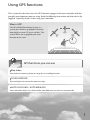
Using GPS functions
This section describes how to use the GPS functions equipped with your camcorder and also
provides some important notes on using. Read the following instructions and also refer to the
supplied “Operating Guide” before using your camcorder.
What is GPS?
The GPS (Global Positioning System) is a
system that calculates geographical location
from highly accurate US space satellites. This
system allows you to pinpoint your exact
location on the earth.
GPS functions you can use
Map Index
You can find a movie or photo on a map by its recording location.
YOUR LOCATION
You can display the current location on a map.
AUTO CLOCK ADJ / AUTO AREA ADJ
Your camcorder adjusts the clock and the time difference on each area automatically.

6
GB
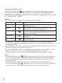
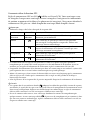
How to use the GPS function
Set the GPS switch to ON ( appears on the LCD screen). Your camcorder starts trying
to triangulate. When your camcorder triangulates successfully, it will record the location
information at the time movies and photos were recorded. You can identify the GPS switch by
the “Operating Guide” supplied.
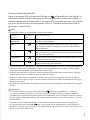
Notes
The indicator changes according to the strength of GPS signal reception.
Triangulating status GPS indicators GPS reception status
Function off No indicator
The GPS switch is set to OFF, or the GPS receiver is not
functioning normally.
Difficult
Your camcorder cannot find a GPS signal, therefore, it cannot
triangulate. Use your camcorder in an open area.
Processing
Your camcorder is confirming the GPS signal, and will be able
to acquire location information soon. Wait until your camcorder
completes the triangulation.
Triangulating
Your camcorder is receiving a GPS signal, and can acquire location
information.
Triangulating
Your camcorder is receiving a strong GPS signal, and can acquire
location information.
The GPS switch is set to ON in the default setting. Movies and photos recorded during triangulation by
GPS will be recorded with location information. If you do not want to record location information, set
the GPS switch to OFF.
It may take from several seconds to several minutes to acquire the location information when you use the
GPS for the first time or use it again after long intervals.
Even if the camcorder is turned off, the GPS function is working as long as the GPS switch is set to ON.
Make sure that the GPS switch is set to OFF during take off and landing of an airplane.
You may not be able to acquire location information depending on the strength of GPS reception.
Tips
The 3 dots in the lower right of
show GPS signal stability. When fewer than 3 dots are displayed, the
GPS signal is not stable enough to triangulate in the current environment. To successfully triangulate,
move to an open area first, and turn the GPS switch to OFF and ON again, or turn the power of your
camcorder off and on.
Your camcorder quits trying to triangulate after a few minutes of unsuccessful attempts. If your
camcorder continues to display
(triangulation process not started) even after moved to an open area,
turn the GPS switch to OFF and ON again, or turn the power of your camcorder off and on.

7
GB
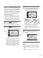
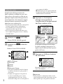
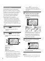
Map Index
Where movies and photos were recorded is
marked on a map. You can select a movie
or photo by recording location. Select the
recording media which contains the movie
or photo you want to play back before
starting this operation.
You can use the Map Index only with movies
and photos having location information that
was recorded with the GPS switch set to ON.
You cannot use the Map Index with photos
recorded on “Memory Stick PRO Duo” media.
Touch (PLAYBACK).
The VISUAL INDEX screen appears.
Touch (Map Index).
You can change the scale using the zoom
lever (W: larger, T: smaller).
The point you touch on the map scrolls
to the center automatically. If you hold a
certain point, the map keeps scrolling.
will appear at the upper right corner
of the thumbnail of the movie or photo
without location information.
Touch the image marker where
you recorded the movies and
photos to be played back.
The image marker turns red. The
movies or photos recorded at that
location are displayed on the left of the
screen.
Touch the desired movie or
photo.
Playback starts from the selected scene.
Notes
Make sure that you set the GPS switch to ON
prior to recording, to be able to create movies
and photos that you can search for on the Map
Index.
The map always displays the north at the top.
Returns to the VISUAL INDEX screen
Scale
Image
marker
Displays photos
Previous
Next

8
GB
Notes
The map always displays the north at the top.
Tips
You can change the scale using the zoom lever
(W: larger, T: smaller).
Your camcorder acquires the current location
information every 10 seconds. The displays
of the center marker, etc., appear differently
according to the status of the current inquiry.
When your camcorder cannot acquire the
current location information, the center marker
turns gray and the map shows the last location
acquired.
If you hold a certain point, the map keeps
scrolling.
You can also display the current location
by touching
(MENU) [ YOUR
LOCATION] (under
[OTHERS] category).
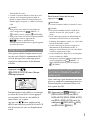
AUTO CLOCK ADJ/AUTO AREA ADJ
Your camcorder can maintain accurate
time and compensate for time difference
automatically, by acquiring time and
location information from GPS.
Touch
(MENU) [AUTO
CLOCK ADJ]/[AUTO AREA ADJ]
(under
[CLOCK/ LANG]
category).
Touch a desired setting
.
Notes
You must set the date and time on your
camcorder before using your camcorder.
There may be discrepancies of a few seconds
even if [AUTO CLOCK ADJ] is activated.
When you record several movies and photos at
the same location, the movie or photo recorded
most recently will be displayed on the LCD
screen.
Tips
You can also display the Map Index by touching
(MENU) [ MAP] (under
[PLAYBACK] category).
You can also search for the thumbnail of the
movie or photo you want to play by touching
/ in step 3. The recording location of
the movie or photo will be displayed at the
center of the map.
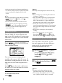
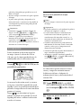
YOUR LOCATION
You can display the current location on a
map. Set the GPS switch to ON so that your
camcorder can acquire the current location
information.
Touch ( YOUR LOCATION) on
the recording screen.
The current location is displayed and
marked at the center of the LCD screen. If
you touch a certain point on the screen, the
map shows the area with that point at the
center.
Touch
(your location) at the bottom
left of the LCD screen to move the current
location back to the center.
To close the map screen
Touch .

9
GB
The clock is adjusted automatically by
[AUTO CLOCK ADJ] when you turn off your
camcorder if the camcorder is receiving a GPS
signal while it is being used. The clock is not
adjusted until the camcorder is turned off. Also,
the clock is not adjusted unless the camcorder
is receiving a GPS signal, even if the GPS switch
is set to ON.
The [AUTO AREA ADJ] function automatically
compensates for a time difference when it
detects a time differences with the current area.
The clock may not be adjusted to the correct
time automatically, depending on the country/
region selected for your camcorder. In this case,
set [AUTO CLOCK ADJ] and [AUTO AREA
ADJ] to [OFF].
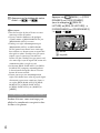
COORDINATES
During playback, your camcorder can
display the coordinates information
recorded on movies and photos.
Touch (MENU) [DATA CODE]
(under [PLAYBACK SET] category)
[COORDINATES]
.
Latitude
Longitude
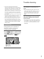
Trouble shooting
The camcorder is not receiving a GPS
signal.
Your camcorder may not be able to receive
radio signals from GPS satellites because of
obstructions. Bring your camcorder to an
open area, and set the GPS switch to ON
again.
The current location on the map of the
camcorder is different from the actual
current location.
The margin of error of the radio signal from
GPS satellites is large. The margin of error can
be as wide as several-hundred meters at the
maximum.

10
GB
radio signals from 3 or more GPS satellites. The
triangulating error allowed by the GPS satellites
is about 30 m (98 feet). Depending on the
environment of the location, the triangulating
error can be greater. In this case, your actual
location may not match the location on the map
based on the GPS information. Meanwhile,
the GPS satellites are controlled by the Unites
States Department of Defense, and the degree of
accuracy may be changed intentionally.
Error during the triangulating process
The camcorder acquires location information
every 10 seconds during triangulating. There
is a slight time difference between when the
location information is acquired and when the
location information is recorded on an image,
therefore, the actual recording location may not
match exactly the location on the map based on
the GPS information.
On the restriction of use of GPS on an airplane
During take off and landing of an airplane,
set the GPS switch to OFF and turn off the
camcorder, as you will be instructed to do by
the on-board announcement. In other cases, use
GPS in accordance with the regulations of the
place or situation.
On the map data
The camcorder contains map data for the
following countries/regions.
Europe, Japan, North America, Oceania, etc.
Built-in map is powered by companies as
follows; Map of Japan by Zenrin Co., Ltd., other
areas by NAVTEQ.
The map data included is as of the date of
production of this manual.
GPS maps will appear in 2-dimensional
graphics except for certain landmarks in Japan,
which will appear in 3D.
The map always displays the north at the top.
You cannot change the language on the map.
You cannot update the map data.
Th
e scale of the map is 25 m to 6,000 km (or
100 feet to 6,000 miles).
About GPS
The GPS system consists of 24 or more GPS
satellites. A GPS receiver receives radio signals
from the satellites, and calculates the current
location of the receiver based on the orbital
information (almanac data) and travel time of the
signals, etc.
Determining a location is called “triangulating.” A
GPS receiver can determine the location’s latitude
and longitude by receiving signals from 3 or more
satellites.
As the positions of GPS satellites vary
constantly, it may take longer to determine
the location or the receiver may not be able to
determine the location at all, depending on the
location and time you use the camcorder.
“GPS” is a system for determining geographic
location by triangulating radio signals from
GPS satellites. Avoid using the camcorder
in places where radio signals are blocked or
reflected, such as a shadowy place surrounded
by buildings or trees, etc. Use the camcorder in
open sky environments.
You may not be able to record location
information at locations or in situations where
radio signals from the GPS satellites do not
reach the camcorder as follows.
In tunnels, indoors or under the shade of
buildings.
Between tall buildings or at narrow streets
surrounded by buildings.
In underground locations, locations
surrounded by dense trees, under an elevated
bridge, or in locations where magnetic fields
are generated, such as near high voltage
cables.
Near devices that generate radio signals of the
same frequency band as the camcorder: near
1.5 GHz band mobile telephones, etc.
On triangulating errors
If you move to another location right after
setting the GPS switch to ON, it may take
a longer time for the camcorder to start
trianguating, compared to when you stay in the
same place.
Error caused by the position of GPS satellites
The camcorder automatically triangulates your
current location when the camcorder receives

11
GB
On the geographic coordinate system
The “WGS-84” geographic coordinate system
is used.
On copyright
The map data of the camcorder is copyrighted.
Unauthorized copying or other usage of the
map data may be contrary to the copyright laws.
On the navigation function
The camcorder does not have a navigation
function that uses GPS.
Australia
Copyright. Based on data provided under license
from PSMA Australia Limited (www.psma.com.
au).
Austria
© Bundesamt für Eich- und Vermessungswesen
Croatia, Estonia, Latvia, Lithuania, Poland and
Slovenia
© EuroGeographics
France
source: Géoroute® IGN France & BD Carto® IGN
France
Germany
Die Grundlagendaten wurden mit Genehmigung
der zustaendigen Behoerden entnommen.
Great Britain
Based upon Crown Copyright material.
Greece
© EuroGeographics; Copyright Geomatics Ltd.
Hungary
Copyright © 2003; Top-Map Ltd.
Italy
La Banca Dati Italiana è stata prodotta usando
quale riferimento anche cartografia numerica ed
al tratto prodotta e fornita dalla Regione Toscana.
Japan
Norway
Copyright © 2000; Norwegian Mapping Authority
Portugal
Source: IgeoE – Portugal
Spain
Información geográfica propiedad del CNIG
Sweden
Based upon electronic data © National Land
Survey Sweden.
Switzerland
Topografische Grundlage: © Bundesamt für
Landestopographie.

2
FR
VOUS DEVEZ LIRE
ATTENTIVEMENT LE CONTRAT
SUIVANT AVANT D’UTILISER
LE PRÉSENT LOGICIEL.
L’UTILISATION DU LOGICIEL
INDIQUE QUE VOUS ACCEPTEZ CE
CONTRAT.
CONTRAT DE LICENCE
UTILISATEUR FINAL POUR LES
DONNÉES DE CARTE POUR LES
PRODUITS SONY HANDYCAM®
IMPORTANT - À LIRE ATTENTIVEMENT : Ce
Contrat de licence utilisateur final (« LICENCE »)
est un contrat légal entre vous et Sony
C
orporation (« SONY »), le concédant de licence
pour les données de carte contenues dans votre
p
roduit Sony HANDYCAM (« PRODUIT »).
Lesdites données de carte, ainsi que les mises à
jour/mises à niveau à venir, sont désignées ici
par le terme LOGICIEL. La présente LICENCE
couvre uniquement le LOGICIEL. Vous pouvez
utiliser le LOGICIEL uniquement conjointement
à votre utilisation du PRODUIT. En utilisant
le LOGICIEL, vous acceptez d’être lié par les
termes de cette LICENCE. Si vous n’acceptez pas
les termes de cette LICENCE, SONY refuse de
vous accorder une licence du LOGICIEL. Dans
ce cas, vous ne devez pas utiliser le LOGICIEL
et vous devez contacter rapidement SONY afin
d’obtenir des instructions sur la restitution du
PRODUIT complet et du LOGICIEL inclus pour
un remboursement du prix d’achat du PRODUIT.
LICENCE DE LOGICIEL
Le LOGICIEL est protégé par les lois sur les droits
d’auteur et les traités internationaux sur les droits
d’auteur, ainsi que par d’autres lois et traités sur
la propriété intellectuelle. Le LOGICIEL est
concédé sous licence et non vendu.
CONCESSION DE LICENCE
La présente LICENCE vous accorde les droits
suivants sur une base non exclusive :
LOGICIEL. Vous pouvez utiliser le LOGICIEL
sur une unité du PRODUIT.
Usage personnel. Vous pouvez utiliser le
LOGICIEL à des fins personnelles et non
commerciales uniquement.
DESCRIPTION DES AUTRES DROITS ET
LIMITATIONS
Restrictions. Vous ne devez pas transférer
ou distribuer toute partie du LOGICIEL sous
quelque forme que ce soit et quelles qu’en
soient les raisons, sauf autorisation expresse
dans la présente LICENCE. Vous ne devez pas
utiliser le LOGICIEL avec tout produit, système
ou application autre que le PRODUIT. Sauf
disposition contraire dans la présente LICENCE,
vous ne devez pas utiliser ou permettre à un tiers
d’utiliser le LOGICIEL séparément du PRODUIT
(en totalité ou en partie, y compris, mais sans
s’y limiter, les reproductions, émissions ou
extractions ou tout autre travail de quelque forme
que ce soit) à des fins de location ou bail, que des
frais de licence soient perçus ou non. Certaines
juridictions n’autorisent pas la restriction de
tels droits, auquel cas les restrictions ci-dessus
peuvent ne pas s’appliquer à votre cas.
Limitation relative à l’ingénierie inverse, la
décompilation et le désassemblage. Vous ne devez
pas (i) extraire le LOGICIEL du PRODUIT, (ii)
reproduire, copier, modifier, transférer, traduire
ou créer des travaux dérivés du LOGICIEL
en totalité ou en partie, ou (iii) effectuer de
l’ingénierie inverse, décompiler, désassembler
le LOGICIEL de quelque façon que ce soit en
totalité ou en partie quelles qu’en soient les
raisons. Certaines juridictions n’autorisent pas la
limitation de tels droits, auquel cas la limitation
ci-dessus peut ne pas s’appliquer à votre cas.
M
arques commerciales et avis : Vous ne devez
pas retirer, modifier, couvrir ou dégrader toute
marque commerciale ou avis de droits d’auteur
sur le LOGICIEL.
Fichiers de données. Le LOGICIEL peut créer
automatiquement des fichiers de données pour
l’utilisation avec le LOGICIEL. Lesdits fichiers
de données sont considérés comme faisant partie
intégrante du LOGICIEL.
Transfert du LOGICIEL. Vous pouvez transférer
de façon permanente l’ensemble de vos
droits conformément à la présente LICENCE
uniquement dans le cadre d’une vente ou d’un
transfert du PRODUIT, à condition que vous
ne conserviez aucune copie du LOGICIEL,
que vous transfériez la totalité du LOGICIEL
(y compris toutes les copies (uniquement si la
copie est autorisée conformément au Paragraphe
«
Limitation relative à l’ingénierie inverse, la
décompilation et le désassemblage » ci-dessus),
les composantes, les documents imprimés et
multimédia, toutes les versions et mises à niveau

3
FR
du LOGICIEL et de la présente LICENCE) et que
le bénéficiaire accepte les conditions générales de
la présente LICENCE.
Résiliation. Sans préjudice de tout autre droit,
SONY peut résilier la présente LICENCE si
vous ne respectez pas les conditions générales
de cette LICENCE. Dans un tel cas, vous devez
arrêter d’utiliser le LOGICIEL et l’ensemble de
ses composantes. Les dispositions des sections
«
DROITS D’AUTEUR », « ACTIVITÉS
À HAUT RISQUE », « EXCLUSION DE
GARANTIE CONCERNANT LE LOGICIEL »,
« LIMITATION DE RESPONSABILITÉ »,
« INTERDICTION D’EXPORTATION »,
« DIVISIBILITÉ » et « DROIT APPLICABLE
ET JURIDICTION », le Paragraphe
« Confidentialité » de la présente Section et le
présent Paragraphe de la présente LICENCE
restent valables après expiration ou résiliation de
cette LICENCE.
Confidentialité. Vous acceptez de garder
confidentielles les informations contenues dans
le LOGICIEL qui ne sont pas connues du public,
et de ne pas divulguer de telles informations aux
autres sans l’accord écrit préalable de SONY.
DROITS D’AUTEUR
Tous les titres et droits d’auteur contenus dans
le LOGICIEL et relatifs à ce dernier (y compris,
mais sans s’y limiter, les données de carte, images,
photographies, animations, vidéos, données
a
udio, musiques, textes et « applets » incorporés
au LOGICIEL) et toutes les copies du LOGICIEL
sont détenus par SONY, les concédants de
licence de SONY et ses filiales, ses et leurs
concédants de licence ou fournisseurs (lesdits
concédants de licence, filiales et fournisseurs
sont désignés collectivement ci-après par
«
Concédants de licence de SONY »). Tous
les droits non spécifiquement accordés dans la
présente LICENCE sont réservés par SONY ou les
Concédants de licence de SONY.
ACTIVITÉS À HAUT RISQUE
Le LOGICIEL n’est pas insensible aux défaillances
et n’a pas été conçu, fabriqué ou prévu pour
être utilisé dans des environnements dangereux
nécessitant une performance de sécurité intégrée,
tels que les systèmes de communication, de
navigation aérienne ou d’installations nucléaires,
le contrôle du trafic aérien, les appareils de
soutien vital direct ou les systèmes d’armes, où
une panne du LOGICIEL pourrait provoquer
la mort, des blessures personnelles, ou des
dommages physiques ou environnementaux
g
raves (« Activités à haut risque »). SONY,
ses filiales, leurs fournisseurs respectifs et les
Concédants de licence de SONY déclinent
spécifiquement toute garantie explicite ou
implicite concernant l’adaptation aux Activités à
haut risque.
EXCLUSION DE GARANTIE CONCERNANT LE
LOGICIEL
Vous reconnaissez et acceptez expressément
que l’utilisation du LOGICIEL est à vos propres
r
isques. Le LOGICIEL est fourni « EN L’ÉTAT »
et sans aucune garantie de quelque sorte que
ce soit et SONY, ses filiales, leurs fournisseurs
respectifs et les Concédants de licence de SONY
(dans cette section, SONY, ses filiales, leurs
fournisseurs respectifs et les Concédants de
licence de SONY sont désignés collectivement
p
ar « SONY ») DÉCLINENT EXPRESSÉMENT
TOUTE GARANTIE ET CONDITION,
EXPLICITE OU IMPLICITE, ÉMANANT DE LA
LOI OU AUTRE, Y COMPRIS, MAIS SANS S’Y
LIMITER, LES GARANTIES ET CONDITIONS
IMPLICITES DE QUALITÉ, NON VIOLATION,
VALEUR MARCHANDE ET ADAPTATION
À UN USAGE PARTICULIER. SONY NE
GARANTIT PAS QUE LES FONCTIONS
CONTENUES DANS LE LOGICIEL
RÉPONDRONT À VOS BESOINS, OU QUE LE
FONCTIONNEMENT DU LOGICIEL SERA
SANS INTERRUPTION OU SANS ERREUR.
SONY NE GARANTIT PAS ET NE FAIT
AUCUNE DÉCLARATION CONCERNANT
L’UTILISATION, L’INCAPACITÉ À UTILISER
OU LES RÉSULTATS DE L’UTILISATION DU
LOGICIEL EN TERMES D’EXACTITUDE,
DE PRÉCISION, DE FIABILITÉ OU AUTRE.
CERTAINES JURIDICTIONS N’AUTORISENT
PAS L’EXCLUSION DE GARANTIES
IMPLICITES, AUQUEL CAS LES EXCLUSIONS
CI-DESSUS PEUVENT NE PAS S’APPLIQUER À
VOTRE CAS.
Vous comprenez expressément que les données
dans le LOGICIEL peuvent contenir des
informations imprécises ou incomplètes dues au
temps passé, aux circonstances qui ont changé,
aux sources utilisées et à la nature de la collecte de
données géographiques complètes, chacune de ces
causes pouvant mener à des résultats incorrects.
LIMITATION DE RESPONSABILITÉ
DANS CETTE SECTION, SONY, SES FILIALES,
LEURS FOURNISSEURS RESPECTIFS ET
LES CONCÉDANTS DE LICENCE DE SONY
FR

4
FR
SONT DÉSIGNÉS COLLECTIVEMENT PAR
« SONY » DANS LA MESURE MAXIMUM
PERMISE PAR LA LOI APPLICABLE. SONY
N’EST PAS RESPONSABLE DE TOUTE
RÉCLAMATION, DEMANDE OU ACTION,
INDÉPENDAMMENT DE LA NATURE DE
LA CAUSE DE LA RÉCLAMATION, LA
DEMANDE OU L’ACTION, ALLÉGUANT
UNE PERTE OU DES DOMMAGES,
DIRECTS OU INDIRECTS, POUVANT
RÉSULTER DE L’UTILISATION OU LA
POSSESSION DU LOGICIEL, NI DE TOUTE
PERTE DE PROFITS, DE REVENUS, DE
CONTRATS OU D’ÉCONOMIES, NI DE
TOUT AUTRE DOMMAGE DIRECT,
INDIRECT, ACCIDENTEL, SPÉCIAL OU
CONSÉQUENT ÉMANANT DE VOTRE
UTILISATION OU INCAPACITÉ À UTILISER
LE LOGICIEL, D’UN DÉFAUT DU LOGICIEL
OU DE LA VIOLATION DES CONDITIONS
GÉNÉRALES, QU’IL S’AGISSE D’UNE ACTION
CONTRACTUELLE OU EN RESPONSABILITÉ
CIVILE DÉLICTUELLE OU BASÉE SUR UNE
GARANTIE, MÊME SI SONY A ÉTÉ INFORMÉ
DE LA POSSIBILITÉ DE TELS DOMMAGES,
SAUF EN CAS DE FAUTE LOURDE OU DE
MAUVAISE CONDUITE VOLONTAIRE
DE SONY, DE DÉCÈS OU BLESSURE
PERSONNELLE, ET DE DOMMAGES DUS À
LA NATURE DÉFECTUEUSE DU PRODUIT.
DANS TOUS LES CAS, À L’EXCEPTION
DES EXCEPTIONS SUSMENTIONNÉES,
L’ENTIÈRE RESPONSABILITÉ DE SONY
CONFORMÉMENT AUX PROVISIONS DE
LA PRÉSENTE LICENCE SE LIMITE AU
MONTANT RÉELLEMENT PAYÉ POUR LE
LOGICIEL. CERTAINES JURIDICTIONS
N’AUTORISENT PAS L’EXCLUSION
OU LA LIMITATION DE DOMMAGES
CONSÉQUENTS OU ACCIDENTELS,
C’EST POURQUOI LA LIMITATION OU
L’EXCLUSION CI-DESSUS PEUT NE PAS
S’APPLIQUER À VOTRE CAS.
INTERDICTION D’EXPORTATION
VOUS RECONNAISSEZ QUE L’UTILISATION
DU LOGICIEL DANS CERTAINS PAYS,
RÉGIONS, ZONES OU INSTALLATIONS, OU
L’EXPORTATION DES PRODUITS DEPUIS LE
PAYS OÙ LESDITS PRODUITS SONT PRÉVUS
À LA VENTE, PEUT ÊTRE RESTREINTE
OU INTERDITE. VOUS ACCEPTEZ
D’UTILISER LE LOGICIEL OU D’EXPORTER
LES PRODUITS CONFORMÉMENT AUX
LOIS, ORDONNANCES, RÈGLES ET
RÉGLEMENTATIONS APPLICABLES DES
PAYS, RÉGIONS, ZONES ET INSTALLATIONS
EN QUESTION.
DIVISIBILITÉ
Si toute partie de la présente LICENCE venait à
être déclarée invalide ou non exécutable, les autres
parties resteraient valides.
DROIT APPLICABLE ET JURIDICTION
La présente LICENCE est régie par les lois du
Japon sans donner effet à ses dispositions de
conflit de lois ou à la Convention des Nations
Unies sur les contrats de vente internationale
de marchandises, qui est expressément exclue.
Tout litige émanant de la présente licence est
soumis à la compétence exclusive au tribunal
de district de Tokyo, et les parties donnent ici
leur consentement concernant le lieu du procès
et la juridiction dudit tribunal. LES PARTIES
RENONCENT À UN PROCÈS AVEC JURY
CONCERNANT TOUTE AFFAIRE ÉMANANT
DE LA PRÉSENTE LICENCE OU RELATIVE
À CELLE-CI. CERTAINES JURIDICTIONS
N’AUTORISENT PAS L’EXCLUSION DU
DROIT À UN PROCÈS AVEC JURY, AUQUEL
CAS L’EXCLUSION CI-DESSUS PEUT NE PAS
S’APPLIQUER À VOTRE CAS.
CONTRAT COMPLET
Les présentes conditions générales constituent le
contrat complet entre SONY et vous concernant
l’objet du contrat, et supplantent entièrement tout
contrat accord oral ou écrit précédent entre vous à
propos dudit objet du contrat.
UTILISATEUR FINAUX DU GOUVERNEMENT
Si le LOGICIEL est acquis par le gouvernement
américain ou en son nom ou par toute autre
entité appliquant ou se conformant à des
droits similaires à ceux revendiqués par le
gouvernement américain, ledit LOGICIEL est
un « article commercial » conformément à la
définition de ce terme au 48 C.F.R. 2.101 des
réglementations fédérales d’acquisition
(« FAR »), il est concédé sous licence
conformément à la présente LICENCE, et ledit
LOGICIEL livré ou fourni de toute autre façon
que ce soit doit être fourni avec la
« Notice d’utilisation » suivante et doit être traité
conformément à ladite notice :

5
FR
NOTICE D’UTILISATION
NOM DU CONTRACTANT (FABRICANT/FOURNISSEUR) :
SONY CORPORATION
ADRESSE DU CONTRACTANT (FABRICANT/
FOURNISSEUR) : 1-7-1 Konan, Minato-ku, Tokyo,
Japon
Ce LOGICIEL est un article commercial ainsi qu’il est
défini dans la section 2.101 des réglementations
fédérales d’acquisition (« FAR ») et est soumis au
CONTRAT DE LICENCE UTILISATEUR FINAL POUR
LES DONNEES DE CARTE POUR LES PRODUITS
SONY HANDYCAM® aux conditions desquelles ce
LOGICIEL a été fourni.
Si l’agent de négociation, l’agence fédérale du
gouvernement ou le fonctionnaire fédéral
refuse d’utiliser la légende fournie, il se doit d’en
notifier SONY avant de revendiquer des droits
supplémentaires ou de recours associés au logiciel.
Informations sur les marques commerciales
et les droits d’auteur
©1993-2007 NAVTEQ
©2009 ZENRIN CO., LTD.
©H
er Majesty the Queen in Right of Canada ;
©Queen’s Printer for Ontario ; ©Canada Post
Corporation ; GeoBase® ; ©Department of Natural
Resources Canada ; ©United States Postal Service
®2007 ; USPS® ; ZIP+4®

6
FR
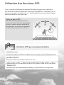
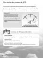
Utilisation des fonctions GPS
Cette section décrit l’utilisation des fonctions GPS dont est équipé votre caméscope et
vous fournit des remarques importantes concernant l’utilisation de ces fonctions. Lisez les
instructions suivantes et reportez-vous au « Mode d’emploi du caméscope/Mode d’emploi »
fourni avant d’utiliser votre caméscope.
Qu’est-ce que le GPS ?
GPS (Global Positioning System) est un
système qui calcule la position géographique
à partir de satellites spatiaux américains de
haute précision. Ce système vous permet de
localiser votre position exacte sur la terre.
Fonctions GPS que vous pouvez utiliser
Index des cartes
Vous pouvez retrouver un film ou une photo sur une carte grâce à son lieu d’enregistrement.
VOTRE POSITION
Vous pouvez afficher la position actuelle sur une carte.
[REGL.HORL.AUTO] ou [RÉGL.HORL.AUTO]/[REGL.ZONE AUTO] ou [RÉGL.
ZONE AUTO].
Votre caméscope règle automatiquement l’horloge et le fuseau horaire sur chaque zone.

7
FR
Comment utiliser la fonction GPS
Réglez le commutateur GPS sur ON ( s’affiche sur l’écran LCD). Votre caméscope essaye
de trianguler. Lorsque votre caméscope réussira à trianguler, il enregistrera les informations
de position au moment où les films et les photos ont été enregistrés. Vous pouvez identifier le
commutateur GPS grâce au « Mode d’emploi du caméscope/Mode d’emploi » fourni.
Remarques
L’indicateur change selon la force du signal de réception GPS.
Etat de la triangulation Indicateurs GPS Etat de réception GPS
Fonction
désactivée
Aucun
indicateur
Le commutateur GPS est réglé sur OFF, ou le récepteur GPS ne
fonctionne pas normalement.
Difficile
Votre caméscope ne parvient pas à détecter un signal GPS.
Par conséquent, la triangulation est impossible. Utilisez votre
caméscope dans un endroit dégagé.
Traitement
Votre caméscope vérifie le signal GPS et pourra prochainement
acquérir les informations de localisation. Attendez que votre
caméscope ait terminé la triangulation.
Triangulation
Votre caméscope capte un signal GPS et peut acquérir les
informations de localisation.
Triangulation
Votre caméscope capte un signal GPS fort et peut acquérir les
informations de localisation.
Le commutateur GPS est réglé sur ON par défaut. Les films et les photos enregistrés pendant la
triangulation par le système GPS seront enregistrés avec des informations de localisation. Si vous ne
souhaitez pas enregistrer d’informations de localisation, réglez le commutateur GPS sur OFF.
L’acquisition des informations de localisation peut durer un certain temps si vous utilisez le système GPS
pour la première fois ou si vous l’utilisez à nouveau après une période prolongée.
Même si le caméscope est hors tension, la fonction GPS reste active aussi longtemps que le commutateur
GPS est réglé sur ON. Vérifiez que le commutateur GPS est réglé sur OFF pendant le décollage et
l’atterrissage d’un avion.
Selon la puissance de la réception GPS, il peut être impossible d’acquérir les informations de localisation.
Conseils
Les 3 points dans le coin inférieur droit de
indiquent la stabilité du signal GPS. Si moins de 3 points
sont affichés, le signal GPS n’est pas assez stable pour effectuer la triangulation de l’environnement actuel.
Pour réussir la triangulation, déplacez-vous d’abord jusqu’à un endroit dégagé et réglez le commutateur
GPS sur OFF et remettez-le sur ON, ou éteignez et rallumez votre caméscope.
En cas de tentatives infructueuses, votre caméscope abandonne la tentative de triangulation après
quelques minutes. Si votre caméscope affiche
(le processus de triangulation n’a pas commencé) alors
que vous avez rejoint un endroit dégagé, réglez le commutateur GPS sur OFF et remettez-le sur ON, ou
éteignez et rallumez votre caméscope.

8
FR
Index des cartes
L’emplacement d’enregistrement des
films et photos est indiqué sur une carte.
Vous pouvez sélectionner un film ou une
photo par emplacement d’enregistrement.
Avant l’opération, sélectionnez le support
d’enregistrement contenant le film ou la
photo que vous souhaitez lire.
Vous ne pouvez utiliser Index des cartes qu’avec
les films et photos dont les informations
de localisation ont été enregistrées avec le
commutateur GPS réglé sur ON.
Vous ne pouvez pas utiliser Index des cartes
a
vec les photos enregistrées sur un « Memory
Stick PRO Duo ».
Appuyez sur (LECTURE).
L’écran VISUAL INDEX apparaît.
Appuyez sur
(Index des
cartes).
Retour à l’écran VISUAL INDEX
Affiche les photos
Précédent
Suivant
Echelle
Marqueur d’image
Vous pouvez modifier l’échelle à l’aide de
la manette de zoom (W : plus grande, T :
plus petite).
Lorsque vous appuyez sur un point de
la carte, l’écran défile pour le centrer
automatiquement sur la carte. Si vous
maintenez le doigt sur un certain point, la
carte continue de défiler.
s’affiche dans le coin supérieur droit de
la vignette des films ou photos dépourvus
d’informations de localisation.
Appuyez sur le marqueur
d’image correspondant à
l’emplacement d’enregistrement
des films et photos à lire.
Le marqueur d’image devient rouge.
Les films ou photos enregistrés à cet
emplacement s’affichent dans la partie
gauche de l’écran.
Appuyez sur le film ou la photo
de votre choix.
La lecture commence à partir de la
scène sélectionnée.
Remarques
Veillez à régler le commutateur GPS sur ON
avant l’enregistrement afin de pouvoir créer des
films et photos que vous pourrez rechercher

9
FR
Pour fermer l’écran de la carte
Appuyez sur .
Remarques
Le nord est toujours affiché en haut de la carte.
Conseils
Vous pouvez modifier l’échelle à l’aide de la
m
anette de zoom (W : plus grande, T : plus
petite).
Votre caméscope acquiert les informations de
lo
calisation actuelles toutes les 10 secondes.
L’affichage du marqueur central, etc., varie selon
l’état de la demande actuelle.
Si votre caméscope ne peut pas acquérir les
informations de localisation actuelles, le
marqueur central devient gris et la carte affiche
le dernier emplacement acquis.
Si vous maintenez le doigt sur un certain point,
la carte continue de défiler.
Vous pouvez également afficher l’emplacement
actuel en appuyant sur
(MENU)
[
VOTRE POSITION] (sous la catégorie
[AUTRES]).
REGL.HORL.AUTO ou RÉGL.HORL.
AUTO/REGL.ZONEAUTO ou RÉGL.
ZONE AUTO
Votre caméscope peut maintenir une heure
précise et compenser automatiquement les
fuseaux horaires en obtenant l’heure et le
lieu à partir du GPS.
Appuyez sur
(MENU)
[REGL.HORL.AUTO] ou [RÉGL.
HORL.AUTO]/[REGL.ZONE AUTO]
ou [RÉGL.ZONE AUTO] (sous la
catégorie [REG.HOR./ LAN.]
ou [RÉG.HOR./ LAN.]).
dans l’Index des cartes.
Le nord est toujours affiché en haut de la carte.
Lorsque vous enregistrez plusieurs films et
photos au même endroit, le dernier film ou la
dernière photo enregistré (e) s’affiche sur l’écran
LCD.
Conseils
Vous pouvez aussi afficher l’écran Index des
cartes en appuyant sur
(MENU)
[
CARTE] (sous la catégorie [LECTURE]).
Vous pouvez aussi rechercher la vignette du film
ou de la photo à lire en appuyant sur
/ à l’étape 3. L’emplacement
d’enregistrement du film ou de la photo apparaît
au centre de la carte.
VOTRE POSITION
Vous pouvez afficher l’emplacement actuel
sur une carte. Réglez le commutateur GPS
sur ON afin que votre caméscope puisse
acquérir les informations de localisation
actuelles.
Appuyez sur
( VOTRE POSITION) dans l’écran
d’enregistrement.
VOTRE POSITION
L’emplacement actuel s’affiche et est marqué
au centre de l’écran LCD. Si vous appuyez
sur un point à l’écran, la carte affiche la
zone centrée sur ce point.
Appuyez sur
(votre emplacement)
dans le coin inférieur gauche de l’écran LCD
afin de recentrer la carte sur l’emplacement
actuel.

10
FR
Appuyez sur (MENU) [CODE
DONNEES] ou [CODE DONNÉES]
(sous la catégorie [REGL.DE
LECTURE] ou [RÉGL.DE LECTURE])
[COORDONNEES] ou [COORDONNÉES]
.
Latitude
Longitude
Appuyez sur le réglage de votre
choix
.
Remarques
Vous devez régler la date et l’heure sur votre
caméscope avant de l’utiliser.
Il peut y avoir des différences de quelques
secondes même si [REGL.HORL.AUTO] ou
[RÉGL.HORL.AUTO] est activé.
L’horloge est réglée automatiquement par
[REGL.HORL.AUTO] ou [RÉGL.HORL.
AUTO] quand vous mettez votre caméscope
hors tension si ce dernier reçoit un signal GPS
alors qu’il est utilisé. L’horloge n’est pas ajustée
jusqu’à ce que le caméscope soit mis hors
tension. De plus, l’horloge n’est pas ajustée sauf
si le caméscope reçoit un signal GPS, même si le
commutateur GPS est réglé sur ON.
La fonction [REGL.ZONE AUTO] ou [RÉGL.
ZONE AUTO] compense automatiquement
le fuseau horaire lorsqu’elle détecte le fuseau
horaire de la zone actuelle.
L’heure peut ne pas être automatiquement
réglée sur la bonne heure selon le pays/la région
sélectionné(e) pour votre caméscope. Dans ce
cas, réglez [REGL.HORL.AUTO] ou [RÉGL.
HORL.AUTO] et [REGL.ZONE AUTO]
ou [RÉGL.ZONE AUTO] sur [ARRET] ou
[ARRÊT].
COORDONNEES ou COORDONNÉES
Pendant la lecture, votre caméscope peut
afficher les coordonnées enregistrées dans
les films et les photos.
La page est en cours de chargement...
La page est en cours de chargement...
La page est en cours de chargement...
La page est en cours de chargement...
La page est en cours de chargement...
La page est en cours de chargement...
La page est en cours de chargement...
La page est en cours de chargement...
La page est en cours de chargement...
La page est en cours de chargement...
La page est en cours de chargement...
La page est en cours de chargement...
La page est en cours de chargement...
La page est en cours de chargement...
La page est en cours de chargement...
La page est en cours de chargement...
-
 1
1
-
 2
2
-
 3
3
-
 4
4
-
 5
5
-
 6
6
-
 7
7
-
 8
8
-
 9
9
-
 10
10
-
 11
11
-
 12
12
-
 13
13
-
 14
14
-
 15
15
-
 16
16
-
 17
17
-
 18
18
-
 19
19
-
 20
20
-
 21
21
-
 22
22
-
 23
23
-
 24
24
-
 25
25
-
 26
26
-
 27
27
-
 28
28
-
 29
29
-
 30
30
-
 31
31
-
 32
32
-
 33
33
-
 34
34
-
 35
35
-
 36
36


dans d''autres langues
- italiano: Sony HDR-TG5V Istruzioni per l'uso
- English: Sony HDR-TG5V Operating instructions
- español: Sony HDR-TG5V Instrucciones de operación
Documents connexes
-
Sony HDR-XR200V Using Guide
-
Sony HDR-XR500V Le manuel du propriétaire
-
-
-
-
-
-
Sony HDR-PJ10 Mode d'emploi
-
Sony HDR-CX300 Mode d'emploi
-